1/7


Maps Measure
8K+다운로드
620.5kB크기
1.5.1(23-05-2023)최신 버전


세부 정보리뷰버전정보
1/7
Maps Measure의 설명
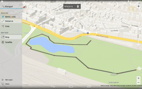
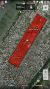
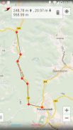
간단한 응용 프로그램은 Google지도에서 거리와 면적을 측정합니다.
그냥 다른 지점을 추가지도를 클릭하세요 -
을지도 한 후 그 지점 사이 * 거리, 면적 또는 높이를 계산합니다 을 측정합니다.
이 응용 프로그램은 같은 경로 또는 뭔가를 계산하지 않습니다 - 그것은 네비게이션 또는 경로 계획 응용 프로그램이 아닙니다.
더 많은 옵션에 액세스하려면 왼쪽에서 스 와이프, 모든 세트 포인트를 삭제하려면 휴지통 아이콘을 길게 클릭합니다.
특징 :
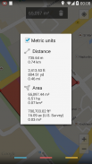
• 측정 거리, 지역 및 고도 *
• 제국 및 미터법 단위
•지도 하이브리드 위성 및 지형보기
• 광고 없음
• 최소 권한 및 오픈 소스
• 안드로이드 4.4에 반투명 시스템 장식에 대한 지원과 함께 홀로 테마로
* 표고 기능을하는 응용 프로그램 내 구입해야합니다 (0.99 EUR, 1.49 USD)
승인 :
인터넷 및 ACCESS_NETWORK_STATE - 고도 데이터를지도를 보여주고 받고
WRITE_EXTERNAL_STORAGE -지도 데이터를 캐싱
ACCESS_COARSE_LOCATION & ACCESS_FINE_LOCATION은 -지도에 현재 위치를 표시
결제 - 응용 프로그램 내 구매를 통해 프로 버전으로 업그레이드
응용 프로그램은 광고를 표시하거나 데이터의 수집하지 않습니다.
응용 프로그램은 오픈 소스와 GitHub의에 나와 있습니다 : https://github.com/j4velin/MapsMeasure
아이콘 https://github.com/amirdesaingrafis에 의해 제공


Maps Measure - APK 정보
APK 버전: 1.5.1패키지: de.j4velin.mapsmeasure이름: Maps Measure크기: 620.5 kB다운로드: 6.5K버전 : 1.5.1출시 날짜: 2024-05-20 18:24:09최소 스크린: SMALL지원되는 CPU:
패키지 ID: de.j4velin.mapsmeasureSHA1 서명: 67:90:F4:3C:F5:9C:1C:87:CF:D8:50:25:3C:73:F0:B8:A1:87:EB:53개발자 (CN): 단체 (O): j4velin-development로컬 (L): 나라 (C): 주/시 (ST): 패키지 ID: de.j4velin.mapsmeasureSHA1 서명: 67:90:F4:3C:F5:9C:1C:87:CF:D8:50:25:3C:73:F0:B8:A1:87:EB:53개발자 (CN): 단체 (O): j4velin-development로컬 (L): 나라 (C): 주/시 (ST):
Maps Measure의 최신 버전
1.5.1
23/5/20236.5K 다운로드620.5 kB 크기
다른 버전들
1.4.4
22/10/20196.5K 다운로드621.5 kB 크기
1.4.3
3/2/20196.5K 다운로드620 kB 크기
1.4
12/11/20166.5K 다운로드902.5 kB 크기


동일 카테고리의 앱


English


